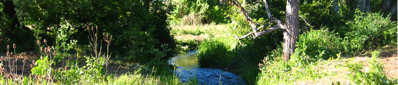
 219 acres located in beautiful Kings Valley were protected through conservation easements in 2006 and in 2014. The conservation values and ecological features of significance include aquatic habitats, riparian areas, wetlands, and remnant oak savannas. Approximately 1.3 miles of the Luckiamute River is on or borders the property and includes associated aquatic, floodplain, and riparian habitats. The conservation easements includes the confluence of Maxfield Creek and Price Creek with the Luckiamute River. There is a seasonal drainage and wetlands located outside of the Luckiamute floodplain that provide important water filtering and wildlife habitat.
Important plant species at the Kings Valley conservation area include prairie species such as Kincaid’s lupine, slender cinquefoil, and plantain.
GLT’s Kings Valley conservation easement builds upon a footprint of protected lands in the Kings Valley region, including Benton County Natural Area and Park’s Beazell Memorial Forest and Fort Hoskins County Park.
Partnerships with landowners like Cliff and Gay Hall and funding from the Oregon Watershed Enhancement Board and Bonneville Power Administration enabled Greenbelt Land Trust to permanently protect this important property through two acquisitions in 2006 and 2014.
“This is what I want to be doing. When asked at 4 years old what I wanted to be when I grew up, I always said that I wanted to be a farmer. Planting these trees, restoring this river … this is what makes us happy. To be leaving this property in a better place for wildlife, water, and our neighbors than we found it.” – Cliff Hall
Restoration
The Management Plan is based on a vision for the property that emphasizes multiples uses of habitat conservation and restoration, agriculture, and education. It was developed to protect the conservation values identified in the conservation easement and designed to be flexible in approaches and methods to meet individual landowner goals.
A primary goal of the Plan and ongoing restoration activities is to identify needs and tasks for maintaining or expanding existing biological resources, such as the riparian zones of Price Creek and Luckiamute River, other rare species and significant habitats, and recommend steps for increasing native biodiversity.
Public access to this conservation easement is currently limited to GLT-led tours and events.