Michael Pope, Executive Director
My grandparents on my mother’s side, Mance and Bertha Warrick Dickens, grew peanuts in the warm chalky soils of their southeast Alabama farm. Like many small farmers in the south, they likely switched to peanuts after the Mexican boll weevil entered Alabama in the early 1900s and devastated cotton crops. Archeologists suspect that peanuts may have originated in the valleys of Peru and Paraguay, and along with cotton and squash were some of the oldest cultivated crops in the Americas. Apparently peanut shaped pottery and ancient jars decorated with peanuts dated to over 3,500 years ago were found in South America, evidence of the longevity of this remarkable plant in human culture. South America Spanish conquistadors on Andalusian warhorses encountered peanuts being sold in the marketplaces when they rode into Tenochtitlan (Mexico City) in the 1520s. Peanuts from South America were carried by Portuguese and Spanish sailing ships to Africa, the Philippines, Southeast Asia and China, and brought to North America in the 1700s perhaps by slaves transported from Africa. Peanuts are self-pollinating legumes and rich in fats, fiber, vitamins and proteins. During hard times, such as the Great Depression, they provided an inexpensive source of nutrition for poor families. Runner, Spanish, Valencia and Virginia are the major types of peanuts grown in the United States. Peanuts are also fed to livestock, and apparently some of the flavor that graces Virginia’s Smithfield hams comes from hogs fed on peanuts. Fire-roasted and boiled peanuts are sold in many street stalls in China; they are the base for many Indonesian dishes such a gado-gado and karedok; they are used in spicy meat stews in Mali, the rich curries in India, and in many other dishes in Africa, Southeast Asia, South and North America, and Europe.
My grandfather’s farm was in Brundidge, a small, quiet town just south of Troy in southeastern Alabama. Brundidge celebrates the annual Peanut Butter Festival which includes the Nutter Butter Parade, the construction of Alabama’s largest PB&J sandwich, a Peanut Butter Run, and a street dance under the stars (serenaded in 2013 by The Dill Pickers). The town had two of the earliest peanut butter mills (Johnston Peanut Butter Mill and the Louis-Anne Peanut Butter Company) in eastern Alabama. Another historical note (nothing to do with peanut butter) from the Brundidge Historical Society says that Eddie Fisher, the singer and paramour of Debbie Reynolds and Elizabeth Taylor, ate at Mrs. Anderson’s Sandwich Shop in Brundidge and that Jerry Lee Lewis performed at the local Armory. Dothan, a larger metropolis to the southeast of Brundidge and near the border of Florida, is the self-proclaimed “Peanut Capitol of the World” and hosts that National Peanut Festival attended by over a 120,000 people.
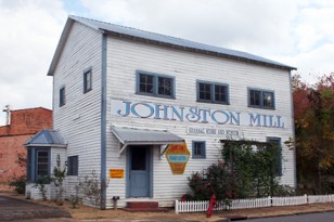
Johnston’s Peanut Butter Mill in Brundidge, Alabama (Brundidge Historical Society)
Oregon is not likely to be an immediate hot spot for peanut farms. However, a few years ago I planted okra in my community garden plot and was harvesting small pods for some creole gumbos in late August. Others at the garden are producing sweet potatoes. The Missoula Floods that swept through the Columbia Gorge in the late Pleistocene deposited some of the richest agricultural soils in the west on the floor of the Willamette Valley. Well drained Abiqua, Chehalis, and Willamette silt loams when seasonally irrigated with waters from the Willamette River or its tributaries are some examples of the highly valued soils in the Willamette Valley that produce an amazing variety of fruits, grains, vegetables, and nuts. Our Saturday Farmer’s Market is an exhibition of the seasonal diversity of foods produced in these wonderfully fertile soils. I spend my Saturday mornings from late April-late November at the Corvallis Farmer’s Market perusing a remarkable and growing array of leafy greens such as Russian and Black kale, spinach, thick-leafed collards, and red-veined Swiss chard, many shapes and forms of yellow, white, and purple potatoes and other hearty root vegetables, numerous varieties of sweet bushberries, an assortment of deep and light red and yellow apples (including my favorite – Gold Rush), Springcrest and Redhaven peaches, Bing and Rainer cherries, several varieties of quince, kiwis and hazelnuts, a dozen or so types of squashes and melons, an emerging assortment of grains such as wheat, rye, and tricale, an astonishing mix of beautifully patterned and colored heirloom beans (including my favorite Snow Caps), a dozen kinds of peppers and tomatoes, Walla Walla sweet onions, and a host of other foods harvested on small farms surrounding our community.
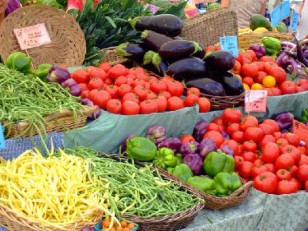
The bounty of crops at the Corvallis Farmers Market.
The American Farmland Trust states that we are losing more than an acre of farmland per minute in America. Between 2002-2007, agricultural lands that equaled the size of Massachusetts were lost because they were converted to developed uses. In many states, land trusts have played a key role in protecting agricultural lands from conversions like developments. The Vermont Land Trust was formed in part to ensure that lands in Vermont with the best farm soils were kept in agricultural uses and that family farms were sustainable and affordable for future generations. The Marin County Land Trust in California has protected nearly 47,000 acres of coastal lands so that farming families who have worked the land for generations can stay on their farms and not be forced to sell because of escalating development pressures. Oregon’s land use laws to some extent provide a buffer for farm lands against development. However, the human population in the Willamette Valley is expected to nearly double in another 40 years particularly in cities, increasing the need for urban areas to expand into agricultural lands. Land protection that includes conservation for fish and wildlife habitats as well as the continued production of farm crops on highly valued agricultural soils may well be an important model to ensure that the Valley’s rich agricultural and natural resource legacies are available for future generations.
In mid-August, Becca and I dropped our kayaks into the Willamette River just north of Corvallis for an afternoon paddle to Albany. The river was filled with canoeist, kayaks, rafts, and inner tubes of various makes, colors and conditions. The river was lazy and slow and our kayaks occasionally scrapped river bottom gravels because of the low flows. I remember on February 8th, 1996 when the waterfront of Corvallis was a sea of umbrellas as citizens excitedly watched the river spill over its banks and flood the eastside. Greater Willamette River floods in 1964 and 1943 discharged far more water. A massive flood in 1861, during Corvallis’s early history, covered over 320,000 acres and washed away many emerging communities. The dams that block the McKenzie, Middle Fork of the Willamette and Santiam Rivers have done the work intended by the army engineers who constructed them so we will not likely experience a flood like 1861. However, I cannot but think the river a few tricks up its sleeve and may again surprise us with its power.
The Pleistocene floods that ravaged the Pacific Northwest were likely some of the most dramatic hydrologic events in earth’s history. Huge glaciers blocked canyons of the Clark Fork River in Idaho and created an enormous 3000 sq mile lake referred to as Lake Missoula. As the glaciers periodically receded the giant lake emptied in massive floods that inundated vast stretches of the Pacific Northwest. The waters surged through the Columbia Gorge transforming the landscape and depositing gravel and giant Pleistocene granite boulders from Montana and Idaho on the low hills and valley floors in the Willamette Basin. The Willamette Valley became a lake, 100 miles long, 60 miles wide and hundreds of feet deep. Geologists suspect that the floods occurred dozens of times over a period of 6,000 years during the Pleistocene with the last event perhaps 13,000 years ago. Another lake, Lake Bonneville, in the present day site of the Great Salt Lake, may have created another massive flood 14,000 years ago that ripped through Hells Canyon and into the Columbia Gorge. The Bonneville and Missoula floods left massive deposits of sediment on the valley floors of the Willamette Basin. There is evidence that humans resided in the Pacific Northwest during the latter periods of the giant floods and perhaps fished and encamped along the lake shores formed by the flood waters.
Bob Duncan, a geologist and geophysicist from Oregon State University, led a tour of Bald Hill Farm this July. Bob grasps the nature of events that span millions of years including the evolution of ocean basins, and the formation of ocean crusts and coastal mountain ranges. While most of us focus our imaginations on our next meals or weekend hikes, Bob’s imagination must roam across geologic epochs. The descriptions of his research and publications includes many wonderful words that I love to say such as “petrogensis” (dealing with the origins of rock particularly igneous rocks), “ophiolite” (serpentine, pillow lava, and chert rock typical of the upper mantel of the earth’s oceanic crust), “mafic” (rock that is rich in magnesium and iron), and “celadonites” (another rock type in the mica group that forms massive prismatic crystallites or clay aggregates), but had to look up to gain some basic understanding of their meanings. The tour provided a brief glimpse of the underlayments of the land that we walk on and, for the most part, take for granted.
The geomorphology of the Willamette Basin and our community shaped the natural history of the ecoregion and is deeply intertwined with eruptions of huge shield volcanos in the Cascades between 17 and 6 million years ago that flooded the valley with basalt, and the ice sheets that covered and etched the valley floor and hillsides for thousands of years. Bob also mentioned that until fairly recently many geologists assumed that the Pacific Northwest was reasonably secure from massive earthquakes similar to the latest one in Japan, but now the data clearly suggests that Washington and Oregon will likely experience a massive 9.0 or greater earthquake perhaps within the next 50 years. This super quake may last for up to 4 minutes and create tsunamis that inundate our coastal communities.
We take for granted that our grand structures such as dams and skyscrapers are incomparable monuments, but compared with the landforms shaped by lava flows, historic floods, and ice sheets, they are inconsequential.